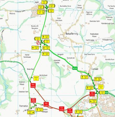
Skip to content
Landrake Parish Council
The A38 running through Landrake Village

Notices and News

Mobile Mast revised proposal

The previous application was withdrawn to allow us to change the design and to reduce height of the proposed mast, as due to technical requirements the site cannot be moved in order to provide coverage to the target area. This proposal is for the installation of a new site to boost the capacity on the network in this location for the operator. The site needs to cover a certain target coverage area as the operator is experiencing capacity issues in this area. The area surrounding the proposed site has been fully investigated, and it was considered that the application site was the most viable and suitable location for the proposed equipment. The search area for the proposed site is small due to the operator’s requirement to fill the hole in coverage to fix coverage and capacity issues currently being experienced by its users. The Phase 9 is the most sensitive and it will be at the lowest possible height of 18m in order to provide clearance on the nearby houses to avoid clipping. The phase 9 monopole is much slimmer in design and are typically not designed to use a wraparound cabinet at the base which reduces the visual impact of the monopole.

Preconsultation letter proposed radio mast at Grass Verge at School Road

6th March 2023

Event Intention - Sir Robert Jefferys School X Country Run

Road Traffic Regulation Act 1984, S.16A
The below event road closure request has been received.
Event: Sir Robert Gefferys School Landrake - Cross Country Run
Date: 10th March 2023
Times: 12:00 to 15:00
Please click the following link for Intention Notice and map : https://one.network/?tm=132797926
Applicants are reminded that they have undertaken to notify all interested parties known to be directly affected by the closure including, if appropriate, bus companies and all frontagers on the length of the road such as local residents and businesses as well as other traders who may have to make deliveries and/or collections in the area.
The event organiser will display notices at each road / street to be closed at least fourteen days before the closure.
Applicants are reminded that they are responsible for the provision, erection, maintenance and removal of all necessary signing and site notices.

Event Intention Notice

3rd February 2023

Clarke Telecom - email response to queries 30/01/2023

Image of Radio Mast location from Clarke Telecom

Clarke Telecom - email response to queries 30/01/2023

It is a densification project for the operator’s network to fill holes in service provision including coverage and capacity. This will enable the operator’s customers to be able to use their handheld devices without calls being dropped or buffering occurring where there is a gap in the operator’s network coverage and capacity ability. A site in this location will fill the gap in service provision and provide high quality, reliable, advanced 4G and 5G to this area. The search area for the proposed site is small due to the operator’s requirement to fill the hole in coverage to fix coverage and capacity issues. The coverage plot below presents current lack of coverage for the operator’s network.

Mobile phone base stations operate on a low power and accordingly base stations therefore need to be located in the areas they are required to serve. Increasingly, people are also using their mobiles in their homes, and this means the operator needs to position base stations in, or close to, residential areas. The proposed mast due to its design will be able to serve only one operator, which is CK Hutchinson Networks (UK) Ltd (commonly known as Three). The proposed new mast has been sited and designed in order to provide 5G coverage and to fill the hole in coverage for this mobile network. At present it is paramount that digital connectivity is supported and maintained throughout the country. The current proposal therefore provides such additional capacity to the network whilst still promoting the improved 5G technology.

The Code of Practice set out the importance of the connectivity in paragraphs 8 – 12:

‘8.Digital connectivity is vital to enable people to stay connected and businesses to grow. Fast, reliable digital connectivity can deliver economic, social and well-being benefits for the whole of the UK.

9.As the demand for mobile data in the United Kingdom is increasing rapidly, it is important that everyone has access to dependable and consistent mobile coverage where they live, work and travel.

10.The Future Telecoms Infrastructure Review (FTIR) and the National Infrastructure Strategy set out the government’s long-term strategy for meeting its digital connectivity targets and delivering high quality, reliable digital infrastructure that works across the UK[1].

11.The government has committed to extending mobile coverage across the UK. The government has committed to extending mobile coverage across the UK. The government’s Levelling Up White Paper has set a mission that the UK will have nationwide 4G coverage, with 5G coverage for the majority of the population by 2030. In support of this, the government and the UK’s mobile network operators agreed a £1 billion Shared Rural Network deal to extend 4G mobile geographical coverage to 95% of the UK by the end of the programme.

12.Next Generation Mobile Technologies: A 5G Strategy for the UK, and the update to this, set out the government’s ambition for the UK to be a global leader in 5G to take early advantage of its potential and help to create a world-leading digital economy that works for everyone. The government also wants businesses and communities to benefit from investments in 5G as soon as possible. Through the government’s 5G Testbeds and Trials programme we have seen its value to manufacturing, farming, transport networks and healthcare.

Also, The Code of Practice notes that new ground-based masts will sometimes be required to accommodate the ever-increasing coverage and capacity needs of the country. 4G and 5G are likely to require further network densification in order to meet growing customer demand for data. Where higher frequencies are used, with lower signal propagation characteristics, apparatus will need to be located in closer proximity to user devices. The type of mast deployed will depend upon the location and setting, as well as the coverage requirements of the site. Therefore, the site at this location will help to meet the government objectives in providing digital connectivity throughout the UK. It is a densification project for the Three operator; therefore the construction cost will be covered by them.

The Frenchmans Lane – Wotton Farm wasn’t taken consideration as it’s located to far to the north in order to provide coverage to the coverage target area; an installation outside this search area, regardless of whether there are existing sites, would not allow the operator to provide their desired level of coverage and therefore would not adequately maintain and provide new coverage and capacity. The current location was chosen by the radio planner, as it’s the most optimal to provide required coverage. There’s not going to be a rental income from the site, as the land on which it’s proposed to be located belongs to the Cornwall Highways.


31st January 2023

PA23 00259

Proposed location

PA23 00259

Email received from Clarke Telecom

Dear Karenza,

I am writing to address some of you concerns.

Addressing your concerns in regard to the highway’s safety, I have forwarded that email to our design and acquisition team for them to look at the matter and comment on that. I can also ensure you that as a part of the planning application the developer’s notice was sent to the Highways Department including a set of site plans for them to comment on it.

Regarding the health concerns the proposed installation conforms to current government planning guidelines regarding potential health effects arising from telecommunications development. The operator has attached a declaration that the site conforms to ICNIRP guidance, as a part of the planning submission. This is in full accordance with NPPF. International Commission on Non-Ionizing Radiation Protection public compliance is determined by mathematical calculation and implemented by careful location of antennas, access restrictions and/or barriers and signage as necessary. Members of the public cannot unknowingly enter areas close to the antennas where exposure may exceed the relevant guidelines.

The suggested alternative location at Quarry Lane would not be more appropriate in my view due to the proximity to the AONB, due to that the development within this sensitive area should be avoided. Siting the telecommunication monopole at this location could meet objections from the case officer, the environment and/or heritage officer due to a possible environmental impact on the Tamar Valley AONB.

Kind regards,
Michal

Site plans

18th January 2023

Proposed 'No waiting at any time' - Church Street

EDG2106_SN02 Church Street

Proposed 'No waiting at any time' - Church Street

To respond, please send any comments or objections, specifying
the grounds on which they are made, via email or in writing to:
Infrastructure Design, CORMAC Consultancy,
Radnor Road, Scorrier, Redruth, TR16 5EH.
Alternatively, please scan the QR Code to respond online
using the Consultation Finder service or visit:
www.cornwall.gov.uk/TrafficConsult

www.cornwall.gov.uk/TrafficConsult

10th January 2023